 |
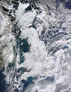
| Britain covered in ice |
I came across
this remarkable image on the BBC News website.
It is Great Britain, seen from space, in its current frozen state. Looking at all that ice I had to wonder to myself, where are the cities? Where is London? Birmingham? Leeds? Grasmere?
How about Carlisle? And Dublin, Dundee, Humberside?
Apparently frozen, too. With Google Earth it was a (cold) snap to find out exactly where the towns lie beneath all that white. I simply used the "Add Image Overlay" feature as seen below.
By saving the frozen Britain image to my desktop, I was able to import it to Google Earth as an overlay and position it (using a series of green "handles" and a transparency slider) until it matched exactly the shape of Britain in Google Earth.
When I was done I saved the place and gave it a title (now it appears in "My Places") and I turned the transparency back to 100% opaque.
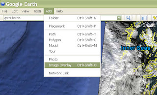 |
| Add image overlays using Google Earth (click to enlarge) |
Last of all, in the sidebar I turned on "Borders and Labels" to see where cities and towns were on top of the "frozen Britain" image. Brrrr!


